|
3rd Ave Beach Overview
While Third Avenue lacks the plush park amenities of Coyote Point, the Bay Trail winds through the area - great for walking, biking, and rollerblading. The Third Avenue windsurfing access was created through the persistent efforts of the SFBA - the San Francisco Boardsailing Association. In 2004 SFBA funded the addition of a rinse station which is particularly appreciated after low-tide sessions.
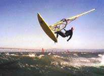
Third Avenue's greatest charm is on the water: strong wind, big swell, open waters, great ramps, and long wild rides. The lack of obstructions near shore give Third Avenue strong steady winds fairly close to shore. The long fetch, shallow sand bars, and favorable currents make for spectacular swell in the 2-5 foot range. On epic NW-wind ebb-tide days, 6-8 foot swells roll through the channel. This is a great place for jumping and swell riding.
The sailing area is huge and you can go for miles. However, the side-offshore winds make breakdown way outside very serious. Sail with a buddy, carry an emergency kit including a whistle, line, and a strobe -- and consider carrying a marine band VHF radio (modern ones are the size of a cell phone) if you roam far from shore.
It can be crowded near the launch area both in the water and on land. The rigging area is tiny. DO NOT RIG IN THE PARKING LOT! You launch down concrete paver ramps set into the rip-rap shore line. The bottom near the launch is soft (but not sticky) mud. If the tide is below 2.0 feet at the new launch site or 1.5 feet at the Old Third Avenue launch site (near the blue tanks) you will have problems with the mud. At tides below 2.0 feet, the four sand bars between the launch and the channel create a serious hazard. There is a bar along the edge of the channel from the channel marker towards the bridge. Another bar is about halfway from the old launch to the channel marker. There are also two bars within 400 yards of the new launch stretching upwind starting on a line between the new launch and the channel marker. All of these bars can be very dangerous at lower tides. Beginners can launch from the beach cove near the entrance of the parking area where the side onshore winds keep them out of trouble.
The season starts with strong NW clearing winds in late March or April. These occur off and on through June. During the summer, thermal winds continue well into September but gradually get weaker. In the Spring clearing wind conditions, sail sizes commonly range from 4.0 to 5.0. In the Summer thermal winds conditions, sails in the 5.0 to 6.0 are more common. In the Spring, a full suit is recommended. In the Summer, lighter weight suits will do and short sleeve suits are sometimes used on warmer days *although full suits are recommended to survive a major breakdown far out in the Bay.
Beginners can practice in the beach cove downwind since the wind is side-onshore there. In the outer waters, the wind is side-offshore and the swells are large so only intermediate and advanced sailors should cruise these waters.
Non-sailing family members can also check out the golf driving range next to the launch. No-Parking signs are enforced.
|
 |
Local Expert?  Edit this Page! Edit this Page!
|
