| View previous topic :: View next topic |
| Author |
Message |
WNDZRFR

Joined: 28 Mar 2000
Posts: 124
Location: Greater East Bay Area
|
 Posted: Sat Sep 02, 2023 12:14 pm Post subject: Wind Forecast Write Up Posted: Sat Sep 02, 2023 12:14 pm Post subject: Wind Forecast Write Up |
 |
|
Mike,
The only people that have knowledge to access all of the following are usually those that don't pay for iwindsurf! If you are going to say the following then you need to include links to each item. Thanks
Todays Assignment: 1. Go to any page that shows the Surface isobars over the eastern Pacific. 2. Notice the huge hungry North Pacific High extending from near Japan and over Hawaii to about 200 miles from your house. 3. Notice the tiny 100-mile-wide low-pressure centered just off Pt. Arena blocking the NW ocean winds. 4. Ponder how such a tiny critter could block such a massive beast. 5. Now go to a page that shows the eastern Pacific but at the 500 MB. level. 6. Sort of scary, huh, That Cut Off Low is only 1000 miles wide but its 40-70 mph winds are centered right over Pt. Arena to San Francisco creating and reinforcing that tiny surface low. 7. That Cut Off Low departs Monday. So why am I forecasting NW clearing winds for that day?
_________________
Sponsored by Starboard and The Loft |
|
| Back to top |
|
 |
windfind
Joined: 18 Mar 1997
Posts: 1905
|
|
| Back to top |
|
|
windsrf
Joined: 01 May 1998
Posts: 464
|
| Posted: Sun Sep 03, 2023 1:39 pm Post subject: |
|
|
Mike,
Just noticed that your Daily Briefing for Pt. Isabel differs dramatically from "Gray Line" on the Classic site? I'll try to attach a screenshot for clarity.
I recall you informed us long ago of why this happens, but would appreciate a reminder?
Thanks, David
| Description: |
|
| Filesize: |
1.26 MB |
| Viewed: |
10411 Time(s) |

|
|
|
| Back to top |
|
|
WNDZRFR
Joined: 28 Mar 2000
Posts: 124
Location: Greater East Bay Area
|
| Posted: Sun Sep 03, 2023 3:50 pm Post subject: |
|
|
This links drawing is Greek to me - https://ocean.weather.gov/Pac_tab.php and not very helpful for someone who went through the Oakland Public School system.
Now your West Coast Blog is quite understandable and a link to it should be included in your forecasts when these conditions are present!
Thanks
_________________
Sponsored by Starboard and The Loft |
|
| Back to top |
|
|
windfind
Joined: 18 Mar 1997
Posts: 1905
|
| Posted: Mon Sep 04, 2023 10:18 am Post subject: |
|
|
| WNDZRFR wrote: | This links drawing is Greek to me - https://ocean.weather.gov/Pac_tab.php and not very helpful for someone who went through the Oakland Public School system.
Now your West Coast Blog is quite understandable and a link to it should be included in your forecasts when these conditions are present!
Thanks |
WNDZRFR,
You are embarrassing me. I screwed up.
I pride myself on trying to make things as understandable as possible in the time available. I think that is why I was a good college professor.
In this case, I sent you and others off to government pages with all the promised imagery but with absolutely no explanation about what you were seeing.
I realized this after writing my response to you. Hence, the blog where I tried to explain things.
These blogs take time and Weatherflow needs to know people enjoy them so be sure to use the feedback link in the forecast.
Thanks,
Mike
|
|
| Back to top |
|
|
windfind
Joined: 18 Mar 1997
Posts: 1905
|
| Posted: Mon Sep 04, 2023 12:00 pm Post subject: |
|
|
| windsrf wrote: | Mike,
Just noticed that your Daily Briefing for Pt. Isabel differs dramatically from "Gray Line" on the Classic site? I'll try to attach a screenshot for clarity.
I recall you informed us long ago of why this happens, but would appreciate a reminder?
Thanks, David |
Hi David,
The following is true for many launch sites in the Bay Area:
The "Gray Line" is the modeled winds from our 1 km WF-WRF model which is a version of the WRF which has been adjusted for local topography and sometimes AI and machine learning from previous data. Our WF-WRF model is the highest resolution model available for the Bay Area. However, like all models, it forecasts wind for a 1x1 km or larger grid that covers the entire USA. So, the grid is not centered over the sailing Pt. Isabel sailing area.
In the human forecast, I try to correct the model forecast based on many variables. The sensor is located at a windier point than at the launch area and of course, the winds are usually stronger towards Brooks Island. The sensor is also higher than a person's mast so it records stronger winds. Also, the model often does not "see" WNW winds coming from Marin or warm air moving in from the East Bay flatlands during heat waves.
So in the human forecast i TRY to correct for those variables. IF I forecast the launch sites winds then people will complain that the winds outside were much stronger than my forecast. If I forecast the winds outside people will complain that the launch site's winds were way weak and unreliable.
So, what I do is to try to forecast the winds in the area where you are first able to get on a plane. I am hoping that no one will complain if they find stronger winds outside. This worked well when there were only windsurfers on the water. Then kites made wind forecasting tricky since there are stronger winds at the kite level than at the sail level. Then foils came along which need very little wind once the foil lifts.
Generally, you will find the most useful forecast by looking at a site's table and reading the text right below the table. But personally, i use a forecast mostly to determine if it is worth the drive to launch sites. NOT which size sail/wing/kite to rig.
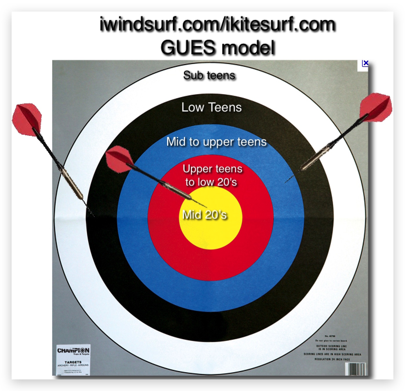
Actually, the model I use the most in forecasting is in the image below!
Mike Godsey
Weatherflow
| Description: |
|
| Filesize: |
398.5 KB |
| Viewed: |
10314 Time(s) |
|
|
|
| Back to top |
|
|
windsrf
Joined: 01 May 1998
Posts: 464
|
| Posted: Mon Sep 04, 2023 1:28 pm Post subject: |
|
|
Mike,
All makes sense - including the dart board.... 
Lately Some of us have decided that the PI sensor has been reading "low" due to winds heading north over by Brooks, rather than continuing eastward towards the sensor.
We finners have compensated by assuming we will have to slog out closer to the "structure" to access that more westerly windline. The steam from a refinery stack also informs us at times - as does Berkeley Reef sensor.
I suppose we should consider launching from Vincent or Shimada, but those are further for driving, plus hate the Shimada steps, plus harder to get offshore from launch, plus low tides don't work there due to muck.
Anyway, appreciate the details as always.
Thanks, David
|
|
| Back to top |
|
|
WNDZRFR
Joined: 28 Mar 2000
Posts: 124
Location: Greater East Bay Area
|
| Posted: Mon Sep 04, 2023 1:38 pm Post subject: |
|
|
Mike,
For those of us regulars at PI we whole heartedly agree with your GUES Model  ! It is known that forecasting PI is not an easy task like other bay sites. ! It is known that forecasting PI is not an easy task like other bay sites.
Over the last so many years we have noticed the East Bay wind direction has clocked more towards PI (SW, SSW) than Berkeley (W, SW). Take my PI/HLS sessions this year - 82 planning sessions with only 5 at HLS. In the not so distant past it was closer to 60/40 PI/HLS. Do you have any thoughts on the changing wind direction for this to occur or do we just chalk it up to climate change like everything else?
And as for the PI sensor readings and location (south of the launch, high up on a pole and inland) I feel the local consensus is it reads low, not high to the actual wind we sail in not very far from the launch.
_________________
Sponsored by Starboard and The Loft |
|
| Back to top |
|
|
dllee
Joined: 03 Jul 2009
Posts: 5329
Location: East Bay
|
| Posted: Mon Sep 04, 2023 3:16 pm Post subject: |
|
|
I wonder if direction of wind is as important as neighboring highs and lows....
At least 5 of my best windsurfing days this season are on SW to slightly SSW wind directions when both Berk and PI are blowing 5.5 sail weather.
At least 10 days if "no wind" at Berk, when PI is 5.0 weather, but most of those would gave been fine on foils and 5.5-6.5 sails.
We all know PI blows stronger than Berk, and has for over 40 years.
Just Berk's lower winds can start in mid March, and go into early Oct most years...
|
|
| Back to top |
|
|
WNDZRFR
Joined: 28 Mar 2000
Posts: 124
Location: Greater East Bay Area
|
| Posted: Tue Sep 05, 2023 12:07 am Post subject: |
|
|
I agree to disagree! HLS always blew stronger than PI until maybe the last decade. Before that I hardly ever needed to (get in the traffic) and go to PI because the Berkeley wind was always stronger and more consistent.
I don't think I have seen you at PI more than a hand full of times and if the wind is soo much better at PI why aren't you there on your small sails taking advantage of it?
Now a days when the wind goes SSW, PI is mediocre at best which by the way has been happening very frequently this season. The wind used to come through the gate and head straight for Berkeley, now it comes in the gate and curves up the bay.
Maybe over the years the max gradient to Sac has just become stronger than the gradient to Stockton and Bakersfield, well that and Eddy who seems to be a mainstay now.
_________________
Sponsored by Starboard and The Loft |
|
| Back to top |
|
|
|
|
You cannot post new topics in this forum
You cannot reply to topics in this forum
You cannot edit your posts in this forum
You cannot delete your posts in this forum
You cannot vote in polls in this forum
You can attach files in this forum
You can download files in this forum
|
|
|

