| View previous topic :: View next topic |
| Author |
Message |
windfind
Joined: 18 Mar 1997
Posts: 1901
|
 Posted: Fri May 19, 2017 9:56 am Post subject: Updated: The heat fades then: David vs Goliath Posted: Fri May 19, 2017 9:56 am Post subject: Updated: The heat fades then: David vs Goliath |
 |
|
Hi Gang,
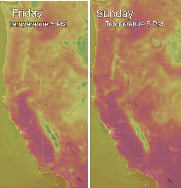
The North Pacific High is shoving a ridge into the Pacific Northwest and far Northern California. So our ocean winds turn a bit more NNW, the heat goes up, eddies form and for most locales the wind goes down.
The image below shows in red the temperature changes Friday and Sunday.
This video link shows the North Pacific High forming that huge high pressure ridge:
http://blog.weatherflow.com/west-coast-wind-blog-the-heat-is-on/
Mike Godsey
iwindsurf.com/ikitesurf.com
Weatheflow.com
| Description: |
|
| Filesize: |
76.95 KB |
| Viewed: |
22366 Time(s) |
|
Last edited by windfind on Mon May 22, 2017 10:49 am; edited 1 time in total |
|
| Back to top |
|
 |
ctuna
Joined: 27 Jun 1995
Posts: 1126
Location: Santa Cruz Ca
|
| Posted: Fri May 19, 2017 2:13 pm Post subject: |
|
|
Any likely hood of a Marine surge anytime soon .
Like next week maybe?
|
|
| Back to top |
|
|
spanker_jeep

Joined: 15 Mar 2002
Posts: 404
Location: Outer Richmond District.
|
| Posted: Fri May 19, 2017 5:43 pm Post subject: |
|
|
| If you don't mind the stray pitbull wandering around Candlestick is always windy.
|
|
| Back to top |
|
|
windfind
Joined: 18 Mar 1997
Posts: 1901
|
| Posted: Fri May 19, 2017 7:56 pm Post subject: |
|
|
| ctuna wrote: | Any likely hood of a Marine surge anytime soon .
Like next week maybe? |
Hi ctuna,
There are several things that are suggesting a mild marine surge Monday or Tuesday.
1. The high pressure that is currently crushing the marine layer begins to depart.
3. A very large counter-clockwise spinning eddy spins up about 100 miles west of the Bay Area creating southerly flow aloft.
3. Up at ≈ 18,000 ft. an upper trough drifts towards California which deepens the marine layer.
4. The Central Valley thermal low is which will expand over parts of the Bay this weekend retracts back to the Central Valley leaving a lobe of low pressure over Marin, Sonoma and Napa creating a S. to N. pressure gradient.
Hard to call this far out but Monday or Tuesday I expect fog to rush up the coast, pause at Monterey Bay and then zoom to the Golden Gate.
Mike Godsey
iwindsurf.com/ikitesurf.com
Weatheflow.com
|
|
| Back to top |
|
|
ctuna
Joined: 27 Jun 1995
Posts: 1126
Location: Santa Cruz Ca
|
| Posted: Fri May 19, 2017 10:16 pm Post subject: |
|
|
I have seen a Dead Pit Bull in the water at Candlestick.
Two holes where some one ran into the fence this year.
It's been the best place for wind lately .
We are all wondering if it will be accessible at all in the
future. It seems the more things get developed the less
access there is and what there is costs more.
|
|
| Back to top |
|
|
B-Man_6.5
Joined: 27 Oct 2015
Posts: 38
|
| Posted: Sun May 21, 2017 1:50 pm Post subject: |
|
|
| Silly question, but what is a "marine surge"? I've read the forecasts, but I'm still confused.
|
|
| Back to top |
|
|
ctuna
Joined: 27 Jun 1995
Posts: 1126
Location: Santa Cruz Ca
|
| Posted: Sun May 21, 2017 2:42 pm Post subject: |
|
|
I am not the meteorologist here but basically its a big thick
fogbank generated by heat and cold water temps. Once it gets
thick enough to get through the land gaps it generates big winds
do to the temperature difference between the land an sea.
When it gets going you can see the fog boiling at the edge. It usually
produces big winds for places like Rio Vista and San Luis Res in the
bay area if its deep enough . It can also cancel winds for the Bay
Area if it comes in to deep. Generally 2000 to 3000 ft thick is a significant one.
|
|
| Back to top |
|
|
windfind
Joined: 18 Mar 1997
Posts: 1901
|
| Posted: Sun May 21, 2017 4:32 pm Post subject: |
|
|
Hi bmot,
Skipping the meteorology jargon.... here is a marine surge in a time lapse video. Just click on the the image that says "Approaching marine surge"
https://windnotes.smugmug.com/1-Videos-WindsurfKite/1-Gorge-Videos/
The mild marine surge I am guesscasting for Monday PM or Tuesday PM is not as typical as the one in the video or as powerful. But it will bring SW flow and more marine layer cloud into the Bay.
Mike Godsey
iwindsurf.com/ikitesurf.com
Weatheflow.com
|
|
| Back to top |
|
|
windfind
Joined: 18 Mar 1997
Posts: 1901
|
| Posted: Mon May 22, 2017 10:59 am Post subject: |
|
|
Hi Gang,
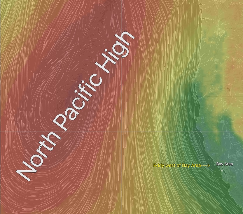
The forecast keep chattering about an "Atypical marine surge". The marine surge that should start this evening or Tuesday morning will be more like a "marine ooze" with the southerly winds ramping up slowly until Wednesday when the winds should really pick up.
This event will be caused by a counter-clockwise spinning surface eddy supported by a sort of mid level Cut-Off Low from about 1000 feet to over 5000 feet.
Meanwhile a powerful North Pacific High continues to rip just several hundred miles to the west.
In the image below you can see the monster NORTH PACIFIC HIGH and the tiny Eddy just west of the Golden Gate. So it is a sort of David vs. Goliath battle being waged just offshore between the tiny eddies S. winds and the N. winds of the giant NPH.
My bet is on David this entire week!
Mike Godsey
iwindsurf.com/ikitesurf.com
Weatheflow.com
| Description: |
|
| Filesize: |
244.16 KB |
| Viewed: |
21971 Time(s) |
|
|
|
| Back to top |
|
|
kevinpurdy
Joined: 05 May 2002
Posts: 19
|
|
| Back to top |
|
|
|

