| View previous topic :: View next topic |
| Author |
Message |
shreddbob

Joined: 31 Mar 1987
Posts: 361
Location: Hawaii
|
 Posted: Fri Aug 02, 2013 2:54 pm Post subject: Next time the forecast is for 6 - 10 I'm jumping on it!! Posted: Fri Aug 02, 2013 2:54 pm Post subject: Next time the forecast is for 6 - 10 I'm jumping on it!! |
 |
|
Too bad the Friday traffic is between me and this wind...wish I'd gotten in the car a few hours ago.
| Description: |
|
| Filesize: |
69.44 KB |
| Viewed: |
14439 Time(s) |

|
| Description: |
|
| Filesize: |
247.92 KB |
| Viewed: |
14439 Time(s) |

|
|
|
| Back to top |
|
 |
flaherty

Joined: 01 May 1997
Posts: 439
|
| Posted: Fri Aug 02, 2013 4:31 pm Post subject: |
|
|
| Yep, this has been the year of the late afternoon wind, kinda like the old days. I did goto BB yesterday, and thought it would happen, got out on a gust , and went nowhere, then it rained on me, as a final insult. This sport gives and takes.
|
|
| Back to top |
|
|
shreddbob
Joined: 31 Mar 1987
Posts: 361
Location: Hawaii
|
| Posted: Fri Aug 02, 2013 4:43 pm Post subject: |
|
|
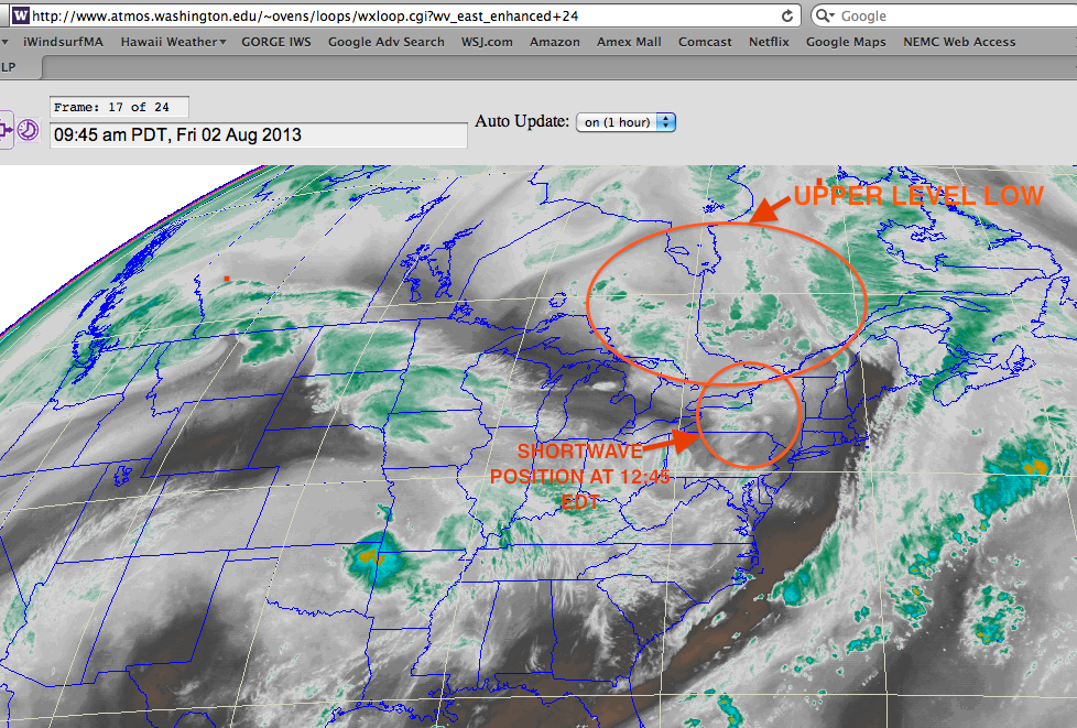
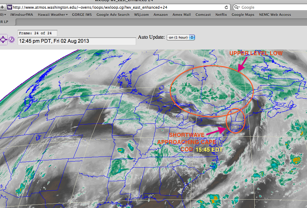
I guess I should've seen this coming. With sunshine after 12 noon, and low pressure in Canada to our north, there was a shortwave rotating around the base of the low, heading our way, which kicked up the SW winds ahead of it. Check out the below Water Vapor images which show the setup nicely. These setups develop quickly provided full sunshine. As of 4:45 pm the shortwave was approaching western Buzzards Bay and Ned's may die off suddenly or shift westerly..but I expect the east side of Buzzards to be strong until 7:00, and the south Cape sites to blow until dark.
If you're looking today you can access this link to see the upper level low spinning and the shortwave approaching:
http://www.atmos.washington.edu/~ovens/loops/wxloop.cgi?wv_east_enhanced+24
| Description: |
|
| Filesize: |
389.9 KB |
| Viewed: |
14389 Time(s) |
|
| Description: |
|
| Filesize: |
418.08 KB |
| Viewed: |
14389 Time(s) |
|
|
|
| Back to top |
|
|
boardsurfr
Joined: 23 Aug 2001
Posts: 1266
|
| Posted: Fri Aug 02, 2013 7:18 pm Post subject: |
|
|
Believe the computer, not the human. The computer models had predicted decent wind for this late afternoon the entire week. As usual in SW winds, the GFS model was closest, but still under predicted. But you know that sun + SW wind means more wind than forecast!
Tomorrow will most likely be better than the forecast, too. I don't believe the drop in the afternoon, either - that when it will get sunny again, just like today. I don't think we'll see gusts in the mid 30s, but averages somewhere in the 20s would not surprise me.
Living close by has its advantages. As happens on most days like this, Bruce and Joanie were already going out when I arrived. Just a few other windsurfers there, though - seems too many believe the meterologists.
|
|
| Back to top |
|
|
justall
Joined: 30 Jul 2007
Posts: 442
|
| Posted: Fri Aug 02, 2013 8:53 pm Post subject: |
|
|
| Yep ... I was skeptical of the forecast, too, but then at about 7 pm some wind showed up in N. Truro. Bascially had to run my gear to the water to score a few runs before I couldn't see. Wish I could be out there now ... Just need headlights on the rig.
|
|
| Back to top |
|
|
jkrouwer
Joined: 10 Apr 2000
Posts: 20
|
| Posted: Sun Aug 04, 2013 2:51 pm Post subject: |
|
|
| So you went to Woodneck today?
|
|
| Back to top |
|
|
wynsurfer
Joined: 24 Aug 2007
Posts: 940
|
| Posted: Sun Aug 04, 2013 6:42 pm Post subject: |
|
|
| I've had about a dozen days this year where the forcast, [national weather service] has been 5-10, only to discover winds of 12-20! These have been mostly south westerlies, and have occured late afternoon as it starts to cool off. I live in eastern Long Island Sound. Whatever is happening, I hope continues. July and August are usually dead. Just this afternoon we saw 15- 20 out of the southwest for an hour or two, forcast was 5-10.
|
|
| Back to top |
|
|
shreddbob
Joined: 31 Mar 1987
Posts: 361
Location: Hawaii
|
| Posted: Mon Aug 05, 2013 3:08 pm Post subject: |
|
|
| jkrouwer wrote: | | So you went to Woodneck today? |
Hey Jan,
Yesterday (Sunday) was interesting day for Buzzards Bay weather. I was invited for day sailing and we cruised down the Bay and back. Wind was light West at noon as we left Marion, but quickly picked up out of SW in middle of the Bay. The Chappy side was blowing a nice 6.5 during early and mid afternoon but as we cruised downwind in the nice SW wind (with a few wind holes of a bit lighter wind) toward Marion 4:30 - 5 the wind died very suddenly a mile out from Bird Island...and as we got closer in it was blowing NW at a good clip.
I think the two factors that prevented a west side of the Bay good SW were:
- Too many instability clouds that side, so thermal not well established
- With warm mid 70's water and air temps in 70's, the thermal potential was not all that great, and not well primed to hold off the WNW flow in general. If this had been May we'd have seen 4.7 at Chappy. (Same issue today, Monday, with the cool air not providing enough thermal kick to turn things strong SW.)
|
|
| Back to top |
|
|
|
|
You cannot post new topics in this forum
You cannot reply to topics in this forum
You cannot edit your posts in this forum
You cannot delete your posts in this forum
You cannot vote in polls in this forum
You can attach files in this forum
You can download files in this forum
|
|
|

