| View previous topic :: View next topic |
| Author |
Message |
windfind
Joined: 18 Mar 1997
Posts: 1901
|
 Posted: Wed May 10, 2017 12:33 pm Post subject: Huge North Pacific High coming our way! Posted: Wed May 10, 2017 12:33 pm Post subject: Huge North Pacific High coming our way! |
 |
|
Hi Gang,
Nice marine surge and SW flow underway today! Remember when that used to happen in July?
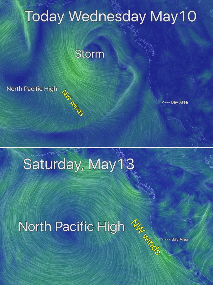
In the top image today (below) you can see the SW flow over the Bay Area that is jazzing up the marine surge. But I want you to focus on the wimpy North Pacific High north of Hawaii in that same image. Note the clockwise rotation of wind around the high and the NW winds far far away from California. Also note the storm WNW of the Pacific Northwest that is keeping the NPH away from our coast.
Now look at the second image of the North Pacific High as modeled for this Saturday. The NPH totally dominates the Pacific from the Gulf of Alaska to Hawaii to California to Baja. This should mean building NW winds towards this weekend.
Mike Godsey
iwindsurf.com/ikitesurf.com
Weatheflow.com
| Description: |
|
| Filesize: |
249.94 KB |
| Viewed: |
8998 Time(s) |
|
|
|
| Back to top |
|
 |
Jorionw96
Joined: 18 Mar 2001
Posts: 33
|
| Posted: Wed May 10, 2017 11:02 pm Post subject: |
|
|
| Mike, how come the wind at Sherman island is so wnw during marine surges these days? It's been that way for years now. I have my theories but curious what you think?
|
|
| Back to top |
|
|
windfind
Joined: 18 Mar 1997
Posts: 1901
|
| Posted: Thu May 11, 2017 10:15 am Post subject: |
|
|
| Jorionw96 wrote: | | Mike, how come the wind at Sherman island is so wnw during marine surges these days? It's been that way for years now. I have my theories but curious what you think? |
HiJorionw96,
The answer to that question is complex and not fully understood at least by me.
But simplified:
1. One reason is that that the average thickness and inland intrusion of the marine layer clouds has been declining in recent decades all along the California coast. The push of marine layer clouds usually has a more southerly component with the strongest winds near the edge of the fog line. So with shallower, less intrusive fog Sherman Island, on the average, has fewer days with a SW push.
2. The pattern of movement of the North Pacific High has also changed. The upper troughs and upper ridges that steer surface features like storms and the NPH have become more accentuated N. to S. in recent decades which has changed the average positioning of the NPH.
10-20 years ago the North Pacific High's surface NW winds were, on the average, very weak in the summer along our coast so the "June Gloom" was the norm. These days we have some years where mild NW wind continues much of the summer. This means that even when the marine layer is deep and Sherman Island blows the wind is a combo of SW and NW which translates into WSW to WNW winds more focused at the Access at Sherman Island rather than towards the power lines.
3. Also the Montezuma Hills create a mild venturi effect at Sherman Island adding a few critical knots to the wind. When the wind is more SW this venturi effect is more focused towards the powerlines. But with WNW winds this venturi effect is focused near the Access while the powerlines area is in a turbulent area down wind from the max venturi. Hence weaker and more up and down winds for the powerlines.
4. Also the wind turbines on the Montezuma Hills create some down stream turbulence. When the wind is more SW this turbulent zone is directed away from the powerlines. But when the wind is more WNW the turbulent zone is over part of the powerline sailing area but not the Access.
5. Despite all of the above when we get a true marine surge after a heat wave and with southerly winds on the ocean Sherman Island gets a deep marine layer clouds nearby and pure SW wind. And then points 1-4 above are absent and the whole river turns to Rio Daze!
Also, it looks like the North Pacific High's surface NW winds will ramp up earlier than the imagery above indicates. So expect building NW winds tomorrow Friday May 12.
Mike Godsey
iwindsurf.com/ikitesurf.com
Weatheflow.com
|
|
| Back to top |
|
|
|
|
You cannot post new topics in this forum
You cannot reply to topics in this forum
You cannot edit your posts in this forum
You cannot delete your posts in this forum
You cannot vote in polls in this forum
You can attach files in this forum
You can download files in this forum
|
|
|

