| View previous topic :: View next topic |
| Author |
Message |
surfdog55
Joined: 02 Apr 2001
Posts: 63
|
 Posted: Wed May 08, 2013 10:52 am Post subject: Blunt Point Posted: Wed May 08, 2013 10:52 am Post subject: Blunt Point |
 |
|
Why is the wind speed unavailable for Angel Island on iwindsurf but Wind Alert has the current wind speeds for Blunt Point? I would think with your IT guys and and the computers should be able to make that leap. Also any plans to move the the wind sensor back to marker 12 at Sherman Island this year or do the kiters have too much clout now.
JT
|
|
| Back to top |
|
 |
airwave
Joined: 29 Jun 2000
Posts: 386
|
| Posted: Wed May 08, 2013 11:14 am Post subject: |
|
|
I agree, we need the Angel Island and Marker 12 sensors back.
There is also a weird phenomenon with the Berkeley sensor. It drops to zero and back up on all the lulls.
Of course that may just be the way Berkeley is.
|
|
| Back to top |
|
|
foiled_again
Joined: 16 Mar 2001
Posts: 33
|
| Posted: Wed May 08, 2013 2:41 pm Post subject: |
|
|
| A couple of years ago I was taking a break and standing in the water at the launch spot at Hs. Lordships. I was watching the gulls overhead as they came and went from their perch on Hs. Lordships roof. They can hover before they land. I noticed one gull hovering over the spinning wind meter then stop the blade with his beak.
|
|
| Back to top |
|
|
windfind
Joined: 18 Mar 1997
Posts: 1905
|
| Posted: Wed May 08, 2013 3:04 pm Post subject: |
|
|
Hi Surfdog,
There are 2 sensors on Point Blunt. One is the old NWS sensor that is located next to the white building in near the middle of the picture below. It is currently out of operation. It is far above the water and in many conditions it reads very HIGH due to a local venturi and its elevation. This is the sensor that appears on the old iwindsurf.com site.
The second sensor belongs to us and it was installed for the America's Cup. It is much closer to the water and lower and is generally more accurate.
In the old days of iwindsurf.com which was the early days of the web we had very few sensors and they were only in the coastal USA. We made the maps by hand in Adobe Illustrator and when we added a new sensor we had to laboriously make a hand entry on the map for each new sensor. That quickly became impractical.
We now, with Windalert.com and all the products that derive from that like sailflow.com, fishweather.com cover the entire world with tens of thousands of sensors. Entering all of those new sites by hand would take a staff of hundreds. However with Windalert.com all we have to do is enter the Lat./Long. of a new sensor and like magic it appears on our google based zoomable maps.
It is just a matter of time until iwindsurf.com and ikitesurf.com convert to the new map format. In the meantime windalert.com has ALL of the old and new Bay Area sensors plus hundreds of public domain sensors plus hundreds of new features. Check it out!
I will look into the data drop for the Berkeley sensor. The issue with the Marker 12 sensor is complex. It has become clear that the new location picks up usable wind that the old location did not. Before we had 2 sensors that were picking up basically the same wind. So far the bulk of customer input favors the new location.
Mike Godsey
iwindsurf.com
| Description: |
|
| Filesize: |
125.83 KB |
| Viewed: |
15716 Time(s) |

|
|
|
| Back to top |
|
|
kevinkan

Joined: 07 Jun 2001
Posts: 1661
Location: San Francisco
|
|
| Back to top |
|
|
surfdog55
Joined: 02 Apr 2001
Posts: 63
|
| Posted: Wed May 08, 2013 4:15 pm Post subject: |
|
|
Thanks Kevin
That sounds easy enough
JT
|
|
| Back to top |
|
|
windsrf
Joined: 01 May 1998
Posts: 464
|
| Posted: Wed May 08, 2013 4:15 pm Post subject: |
|
|
The "data drop" on the Berkeley sensor is too regular to be gull interference IMHO. However, that's definitely an interesting observation!
Thanks Mike for following up on the minor glitch with the lull readings at His Lords.
David
|
|
| Back to top |
|
|
johnarmitage
Joined: 10 Jun 2001
Posts: 108
|
| Posted: Wed May 08, 2013 4:57 pm Post subject: |
|
|
| kevinkan wrote: | | for Blunt Point, can they just replace the data from the old Angel Island sensor on the current iWS map? |
Thats what I would suggest too. The UI and visualization of IWS is superior to that of wind alert. Understand the system scaling issues though....
|
|
| Back to top |
|
|
windfind
Joined: 18 Mar 1997
Posts: 1905
|
| Posted: Wed May 08, 2013 5:16 pm Post subject: |
|
|
| kevinkan wrote: | | for Blunt Point, can they just replace the data from the old Angel Island sensor on the current iWS map? |
Hi Kevin,
Yes, that sounds easy enough. The issue is that customers all over the USA and rest of the world have similar requests. They all know and love the old web site. But the code for iwindsurf.com is ancient and hand moving sensors data on maps for hundreds of sensors is not practical. Even even if we did "remap" it would be a mess when the old sensor came back on line since we would have to remap 2 sensor back to the original layout.
Remember the Blunt Point in question is not even ours. The real solution is to complain to the NWS and move that sensor up in their repair schedule. Once they get is fixed the data will automatically reappear on the old iwindsurf.com map.
Meanwhile just take the time to create your own favorite map with your sites and sensors in Windalert.com and have all the sensors. Then just use iwindsurf.com for the forums until it is converted to the new layout.
Mike Godsey
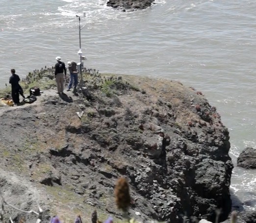
| Description: |
| Installing the new weatherflow.com Blunt Point sensor required 2 boat trips, lots of concrete and a crew of 4. |
|
| Filesize: |
86.6 KB |
| Viewed: |
15635 Time(s) |
|
|
|
| Back to top |
|
|
windfind
Joined: 18 Mar 1997
Posts: 1905
|
| Posted: Thu May 09, 2013 1:15 pm Post subject: |
|
|
Hi Gang,
I just talked to Stuart and the install crew. He says:
"When I'm down there next week, Berkeley will get a new tray that eliminates the problem you're seeing.
It will also get a new vane, we had some unexpected wiring issues during the install."
Mike Godsey
iwindsurf.com
|
|
| Back to top |
|
|
|

