| View previous topic :: View next topic |
| Author |
Message |
peconic_sky
Joined: 24 Jun 2005
Posts: 14
Location: Hampton Bays, NY
|
 Posted: Fri Aug 03, 2007 1:28 pm Post subject: Peconic Bay Flatwater Posted: Fri Aug 03, 2007 1:28 pm Post subject: Peconic Bay Flatwater |
 |
|
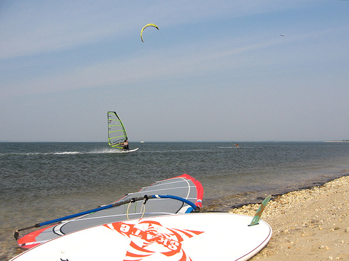
Those who like flatwater on the East End LI should check out Red Cedar Point. It gets nice on a SW 6.2 day like today, plus ramps and swells are on the other side of the sandbar in Flanders Bay. Follow the link for more info. Hope to see people out there!
Jeff
| Description: |
| Red Cedar Point Flatwater |
|
| Filesize: |
100.42 KB |
| Viewed: |
19324 Time(s) |
|
Last edited by peconic_sky on Mon Aug 06, 2007 10:22 pm; edited 1 time in total |
|
| Back to top |
|
 |
beallmd
Joined: 10 May 1998
Posts: 1154
|
| Posted: Sat Aug 04, 2007 9:47 am Post subject: |
|
|
| Is that named after Ned Flanders?
|
|
| Back to top |
|
|
rationalnational
Joined: 20 Apr 2001
Posts: 163
|
| Posted: Sat Aug 04, 2007 9:57 am Post subject: |
|
|
Hidee Ho neighbor
I think Ned mught be a kitef@g.....
|
|
| Back to top |
|
|
flyman
Joined: 09 Jul 2000
Posts: 2
|
| Posted: Mon Aug 06, 2007 10:56 am Post subject: |
|
|
Is this a shallow water site?
When learning new tricks can one just jump back on - or is it a waterstart location?
|
|
| Back to top |
|
|
winddude44
Joined: 20 Jul 2007
Posts: 9
Location: Westchester ny
|
| Posted: Mon Aug 06, 2007 11:01 am Post subject: site info |
|
|
| And... How easy is it to launch, park and what's the best wind direction for sailing here? Thanks, John
|
|
| Back to top |
|
|
peconic_sky
Joined: 24 Jun 2005
Posts: 14
Location: Hampton Bays, NY
|
| Posted: Mon Aug 06, 2007 10:44 pm Post subject: |
|
|
The water is knee to waist deep on low to mid tides, and chin to overhead on high tides. Don't get too close to shore on extra low tide or you'll lose a fin! This site has an excellent tide table. The best wind direction is SW -- SSW and WSW also work, but due SW is best.
You can get to the Point either by upwinding a couple tacks from South Jamesport, or via the Red Creek Pond boat launch. See this map for details, and also the LI Windsurfing Map. Jamesport probably works best - while a parking permit is required, they only hassle you on sunny, dead-air summer weekends.
|
|
| Back to top |
|
|
winddude44
Joined: 20 Jul 2007
Posts: 9
Location: Westchester ny
|
| Posted: Tue Aug 07, 2007 11:44 am Post subject: |
|
|
| Hey Thanks. Will try to make it out there this August or early Sept. I live in mt vernon westchester cty so I need a bit of time to make it worthwhile.
|
|
| Back to top |
|
|
PeconicPuffin

Joined: 07 Jun 2004
Posts: 1830
|
| Posted: Thu Aug 09, 2007 6:39 am Post subject: |
|
|
If you have the opportunity to dial in your session time, try hitting it from South Jamesport on Southwest wind when the tide is coming in. There are both extensive shallow flatwater areas as well as a nice mid-section with jumpable ramps, that as best we can tell is ideal 2 hours after low tide.
_________________
Michael
http://www.peconicpuffin.com |
|
| Back to top |
|
|
|

