| View previous topic :: View next topic |
| Author |
Message |
slambo
Joined: 06 Jul 1992
Posts: 92
|
 Posted: Thu Mar 06, 2014 9:46 am Post subject: El Nino this summer? Posted: Thu Mar 06, 2014 9:46 am Post subject: El Nino this summer? |
 |
|
| Trade winds here in Maui has been absent for the most part this winter now NOAA is predicting possible El Nino this summer- does that mean weaker trades or more Kona conditions for Maui this summer? Anyone remember what it was like in the past during an El Nino?
|
|
| Back to top |
|
 |
windfind
Joined: 18 Mar 1997
Posts: 1901
|
| Posted: Thu Mar 06, 2014 4:14 pm Post subject: Nph/El Nino |
|
|
Hi slambo,
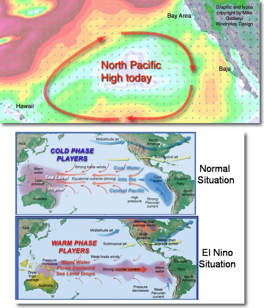
Back from my Baja winter forecasting gig and I just received the latest ENSO Diagnostic Discussion. The current El Nino/La Nina neutral pattern continues through this spring. There are some signs of a El Nino ramping up this summer but so far the chances are only 50% of this occurring according to the models and satellite imagery.
Typically an El Nino means weaker trade winds during the summer for Maui. However the average location of the North Pacific High that generates those Maui trade winds has been atypical this year.
The North Pacific High has been hanging in most of the winter just west of Baja Norte to offshore of Southern California causing the California drought. In this location it brought lots of wind to Baja's East Cape and to parts of the California coast. But this location stopped the El Norte winds from the 4 corners from blowing the length of the Sea of Cortez so the Baja swell was mostly small.
The graph below shows the North Pacific High's location today and how that is impacting the Bay Area, Maui and Baja winds.
Since the North Pacific High is misbehaving location wise it is hard to say how the trade winds will be like this summer even if we get an El Nino.
Mike Godsey
iwindsurf.com
| Description: |
|
| Filesize: |
214.18 KB |
| Viewed: |
12858 Time(s) |
|
Last edited by windfind on Thu Mar 06, 2014 4:50 pm; edited 1 time in total |
|
| Back to top |
|
|
cbknap
Joined: 03 Jun 1997
Posts: 373
|
| Posted: Thu Mar 06, 2014 4:32 pm Post subject: |
|
|
| thanks Mike very interesting.
|
|
| Back to top |
|
|
SWE106

Joined: 14 Feb 2005
Posts: 264
Location: San Mateo
|
| Posted: Thu Mar 06, 2014 6:22 pm Post subject: |
|
|
The chances of an el nino vs. a la nina later this year are 50/50 according to NOAA's el nino latest forecast, which is weekly updated and can be found here (slide 25):
http://www.cpc.ncep.noaa.gov/products/analysis_monitoring/lanina/enso_evolution-status-fcsts-web.pdf
Right now Nino region 3.4 -which is the region used to determine if the ENSO is in an el nino or la nina phase- is still experiencing la nina like conditions with an ONI value (temperature anomaly) of -0.6C... The 3 month running mean of the anomalies in the Nino 3.4 region need to be >+0.5C before an el nino is official. Hence, the equatorial pacific needs to show some real changes soon or we'll likely end the year with another la nada. Given that most of the recent warm oceanic kelvin wave has already passed, a "la nada" (street term for ENSO neutral) or a weak el nino is more likely.
Also of note is that ENSO has most likely entered a la nina dominated phase 3-5 years ago, after having gone through an el nino dominated phase. These phases last around 20-30yrs; the previous one having been an el nino dominated phase, starting in the mid-1970s. This will mean that la nina's will be stronger and more frequent over the next few decades. El nino's will still occur, but less frequent and less strong. In addition to that the PDO has also turned negative, and will likely stay so over the next few decades. It is currently being discussed if the PDO follows ENSO or vice versa. Either way, with both in a negative phase, el ninos stand less change of becoming like the one in 1997/98 or 1987.
A weakening and preferably reversal of the trade winds for a prolonged time is needed to kick off and intensify an el nino. If that doesn't happen then an el nino will neither.
Implications for global surface temperatures are a whole other issue, and we can discuss that another day 
|
|
| Back to top |
|
|
slambo
Joined: 06 Jul 1992
Posts: 92
|
| Posted: Thu Mar 06, 2014 8:59 pm Post subject: |
|
|
thx for the thorough explanation guys. Looks like trades are coming back this weekend into next week here in Maui, hope it lasts for a while.
Aloha
|
|
| Back to top |
|
|
|
|
You cannot post new topics in this forum
You cannot reply to topics in this forum
You cannot edit your posts in this forum
You cannot delete your posts in this forum
You cannot vote in polls in this forum
You can attach files in this forum
You can download files in this forum
|
|
|

