| View previous topic :: View next topic |
| Author |
Message |
windfind
Joined: 18 Mar 1997
Posts: 1901
|
 Posted: Sun Oct 07, 2012 12:06 pm Post subject: El Niño: implications for Gorge, Hawaii, Baja, California Posted: Sun Oct 07, 2012 12:06 pm Post subject: El Niño: implications for Gorge, Hawaii, Baja, California |
 |
|
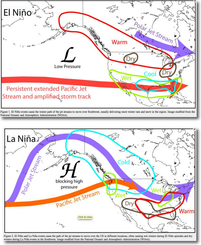
El Niño and La Niña have a major impact on winter and spring winds and weather in the Gorge, Hawaii, Baja, California.
When a winter brings a full blown El Niño develops the storm track over the USA west coast drops more south than normal. And the North Pacific High moves much further south leaving low pressure of lord over the N. Pacific. On the average this means:
Southern California: More storms and rain in the winter and has later and weaker NW clearing winds in the spring since the North Pacific High's surface NW winds are too far to the south.
Hawaii: More Kona conditions than normal. But with the North Pacific High further to the south the NE trade winds are less reliable than normal and have a more easterly direction.
Bay Area About the same as Southern California.
Baja, La Ventana and Los Barriles: Normally dry Baja Norte gets significant rain and it can be very difficult to get into or out of San Carlos.. The big winds on the east cape are caused in large part by the high pressure that moves into the 4 corners (where all the square states meet) after a storm has exited eastward after hitting California. In an El Niño year this high pressure often does not set up in the 4 corners so Los Barriles and La Ventana are less likely to have El Norte winds to push their mid teens local sea breezes into the low 20's. In addition since there are not El Norte winds blowing down the entire length of the Sea of Cortez the swell is smaller.
The Gorge: The Pacific Northwest has less rain/snow than normal. In the spring and summer the wind starts a bit later than normal since it takes longer for the North Pacific High to climb up the coast from the south.
So what are the chances of an El Norte this winter especially in Baja?
Last winter 2011/12 Baja and the west coast was in a La Niña pattern which can produce very good or very weak wind. We lucked out and had great wind but very few big El Norte blows. This winter is more complex. We would expect that this winter would normally be a neural year, No El Niño, no La Niña, since we just finished a La Niña. However this summer there have been hints of a El Niño developing. In recent weeks there has been a slowdown in the development of El Niño conditions. Half of the models indicate that neutral to weak El Niño conditions for this winter and half suggest that a weak El Niño could develop. The official NOAA forecast favors the continuation of neutral to weak El Niño conditions into Northern Hemisphere winter 2012-13, with a chance of a stronger El Niño developing by the holidays.
I will update in the Baja Guide as things become more firm.
Mike Godsey
weatherflow.com
wind alert.com
iwindsurf.com
ikitesurf.com
sailflow.com
fishweather.com
| Description: |
|
| Filesize: |
509.89 KB |
| Viewed: |
19678 Time(s) |
|
Last edited by windfind on Mon Oct 08, 2012 10:31 am; edited 1 time in total |
|
| Back to top |
|
 |
MalibuGuru

Joined: 11 Nov 1993
Posts: 9300
|
| Posted: Sun Oct 07, 2012 5:59 pm Post subject: |
|
|
1982-1998 held the 2 largest El Nino's in recent history. These were the best years for windsurfing in Southern California. After about 2000 the wind progessively lightened down here. I remember at its peak in 82-83 the wind and waves were double mast high at county line, and the Sea Lion Restaurant (Dukes) was destroyed. One particularly large wave blew through the restaurant depositing tables and chairs onto PCH.
The point? I suppose traveling south into Southern Cal or Northern Baja might be the call during these years. Our sport could use a couple of decades of nukin winds like the 80's and 90's down here. I can say for sure that many of us down here have travelled north for wind.....it'll be nice to get the winds back some day. 
|
|
| Back to top |
|
|
gregorvass

Joined: 21 Nov 1996
Posts: 1113
Location: Behind You
|
| Posted: Mon Oct 08, 2012 1:21 pm Post subject: |
|
|
Anomaly apears to be sitting further south then in 1998.
do any of the Meteos think that it is enough to bring jetstream down????
The east coast of Japan apears to be on fire.....does this postpone the forecast into sprin/summer 2013???
| Description: |
|
| Filesize: |
222.44 KB |
| Viewed: |
19387 Time(s) |

|
|
|
| Back to top |
|
|
spennie

Joined: 13 Oct 1995
Posts: 975
Location: Thousand Oaks, CA
|
| Posted: Mon Oct 08, 2012 3:45 pm Post subject: |
|
|
The east coast of Japan appears to be on fire because there's a giant raft of radioactive Tsunami waste headed across the Pacific.
Run for your lives!!!
_________________
Spennie the Wind Junkie
www.WindJunkie.net |
|
| Back to top |
|
|
MalibuGuru
Joined: 11 Nov 1993
Posts: 9300
|
| Posted: Mon Oct 08, 2012 4:09 pm Post subject: |
|
|
| It has brought down some early season NW swell in the 10-14 foot range to Hawaii. Let's hope for some wind for the AWT event later this month!
|
|
| Back to top |
|
|
dllee
Joined: 03 Jul 2009
Posts: 5329
Location: East Bay
|
| Posted: Mon Oct 08, 2012 5:20 pm Post subject: |
|
|
You can try all you want, but you cannot predict what's gonna happen, even if you think an ElNino/LaNina/end of the world prediction is coming.
Weather is too localized to predict in such a long range forecast.
Big swells only mean storms from far away, uninhibited by landmass on it's way to you.
Most years, we on the WestCoast get double overhead days by early Oct., usually WNW swells. It don't mean a thing.
And a big South can happen in Oct, any year.
|
|
| Back to top |
|
|
isobars
Joined: 12 Dec 1999
Posts: 20935
|
| Posted: Mon Oct 08, 2012 5:51 pm Post subject: |
|
|
OTOH, I've definitely seen some seasonal trends, even a decadal trend.
The former: I usually WS out my motor home because most winds "Out East" last for a couple of days, with some whole weeks being saliable most days, so I stay for days or a whole week and need my bed and kitchen with me. I sometimes have to worry about the Corps' 14-days/mo limitations on overnight parking in most of the eastern Gorge area.
Not this year. Not even close. I drove the RV about three times for a single overnighter, and one of those was wasted on a one-dayer. I drove my Subaru almost every trip, and only once had to return the next day for a surprise two-day blow. I've got to guess the reduction in multiple-day blows was at least 90%. That's a pattern, and Godsey explained it with systemic seasonal PacNW logic, just as he did the Bay Area's significant wind pattern changes of late.
Another seasonal difference this year, probably a hitchhiker with the cause of our single-day blows, has been gusty frontal winds in most of the Gorge most of the season instead of the steadier thermal stuff. Those one-sail, all-day, consistent blows we will kill for were almost nonexistent this year ... maybe due to the same pattern that cut my boardies sailing time by 90%.
And yet another seasonal difference this year has been the lack of the well-known "evening push" out east. That's also been off by something like 80% this year.
The decadal trend has been a huge (90%?) reduction in dawn patrol in the corridor since roughly Y2K (Yeah, I know ... Bush did it.) If it were still as common as it was in the '90s, I'd park that moho in the corridor much of the summer and sail my ass off without crowds.
Forecastable on a daily basis? Yes, in the sense that "they" could predict "gusty, short-lived, midday wind" every day they expected any wind, and they'd be right more often than "they" usually are. Come to think of it, "they" -- collectively -- usually did predict gusty, short-lived, midday wind many times this year, and nailed it.
Thus the Subaru ... and a four-digit saving in fuel costs this year for me.
|
|
| Back to top |
|
|
dllee
Joined: 03 Jul 2009
Posts: 5329
Location: East Bay
|
| Posted: Mon Oct 08, 2012 6:00 pm Post subject: |
|
|
Typical SFBayArea forecast...
Low clouds and coastal fog, retreating to near the coast, by afternoonPM's, winds 10-20mph, wind swell 2', with fog intruding into the bay evenings and nights.....
They say that all the time, and some locales have exactly "10-20" moh winds, whiles other's close by (within 2 miles), might hit into the mid 30's.
And other windsurfing spots, zero to 10.
|
|
| Back to top |
|
|
windfind
Joined: 18 Mar 1997
Posts: 1901
|
| Posted: Mon Oct 08, 2012 8:28 pm Post subject: |
|
|
| zirtaeb wrote: | Typical SFBayArea forecast...
Low clouds and coastal fog, retreating to near the coast, by afternoonPM's, winds 10-20mph, wind swell 2', with fog intruding into the bay evenings and nights.....
They say that all the time, and some locales have exactly "10-20" moh winds, whiles other's close by (within 2 miles), might hit into the mid 30's.
And other windsurfing spots, zero to 10. |
Hi Zirtaeb,
It might be nice to define "They" in your comment. For better or worse I have never issued a 10-20 mph forecast anytime much less all the time. I suspect the "They" you are referring to the NWS. They have a 8 man staff forecasting wind and weather many times per day for the Bay Area. They do a hell of a lot better job than I can do when it comes to rain. But I can see job satisfaction advantages to their way of forecasting wind.
Mike Godsey
weatherflow.com
windalert.com
iwindsurf.com
ikitesurf.com
sailflow.com
fishweather.com
USAfishing.com
windnotes.phanfare.com/
|
|
| Back to top |
|
|
dllee
Joined: 03 Jul 2009
Posts: 5329
Location: East Bay
|
| Posted: Mon Oct 08, 2012 8:31 pm Post subject: |
|
|
Well, sure.
You know me, ever the pessimist.
You can see my name in the credits of your Windfinder binders.. pessimist to the max.
|
|
| Back to top |
|
|
|
|
You cannot post new topics in this forum
You cannot reply to topics in this forum
You cannot edit your posts in this forum
You cannot delete your posts in this forum
You cannot vote in polls in this forum
You can attach files in this forum
You can download files in this forum
|
|
|

