| View previous topic :: View next topic |
| Author |
Message |
jimoakes
Joined: 21 Apr 2006
Posts: 172
|
 Posted: Fri Aug 17, 2012 10:31 pm Post subject: Historically when Jones Beach blows till dark the Hatchery.. Posted: Fri Aug 17, 2012 10:31 pm Post subject: Historically when Jones Beach blows till dark the Hatchery.. |
 |
|
| Historically when Jones Beach blows good till dark the Hatchery is windy the next day. I'm hoping thunderstorms don't mess it up.
|
|
| Back to top |
|
 |
gmclean
Joined: 08 Mar 2001
Posts: 91
|
| Posted: Sat Aug 18, 2012 12:09 am Post subject: |
|
|
| We used to talk about the Jones beach/swell city connection. There is already a pretty healthy gradient across the cascades. Hoping for some sailing tomorrow!
|
|
| Back to top |
|
|
isobras
Joined: 17 Jul 2012
Posts: 439
|
| Posted: Sat Aug 18, 2012 7:34 am Post subject: |
|
|
As I've described in another current thread, I've seen Jones get blown off the map for 10 days in a row, for about 18-20 hours each day , while there's nothing but hell itself east of Portland. I've caught those stretches only in mid-Augusts.
Mike \OO/
|
|
| Back to top |
|
|
bmmiller
Joined: 23 May 2007
Posts: 110
|
| Posted: Sat Aug 18, 2012 8:31 am Post subject: |
|
|
| Isobars (aka isobras) is partly right. It really depends upon the strength of the upper ridge. For example, Jones Beach has been blowing until dark the last two days while the Corridor has been baking. The reason the winds will start in the Corridor today is largely because the ridge is getting shoved to the east. However, jimoak is rightly concerned about the thunderstorm chances today. Time will tell!
|
|
| Back to top |
|
|
uwindsurf

Joined: 18 Aug 2012
Posts: 968
Location: Classified
|
| Posted: Sat Aug 18, 2012 9:13 am Post subject: |
|
|
| I sure hope we get some wind today! I am tired of this hot weather.
|
|
| Back to top |
|
|
windfind
Joined: 18 Mar 1997
Posts: 1905
|
| Posted: Sat Aug 18, 2012 9:58 am Post subject: |
|
|
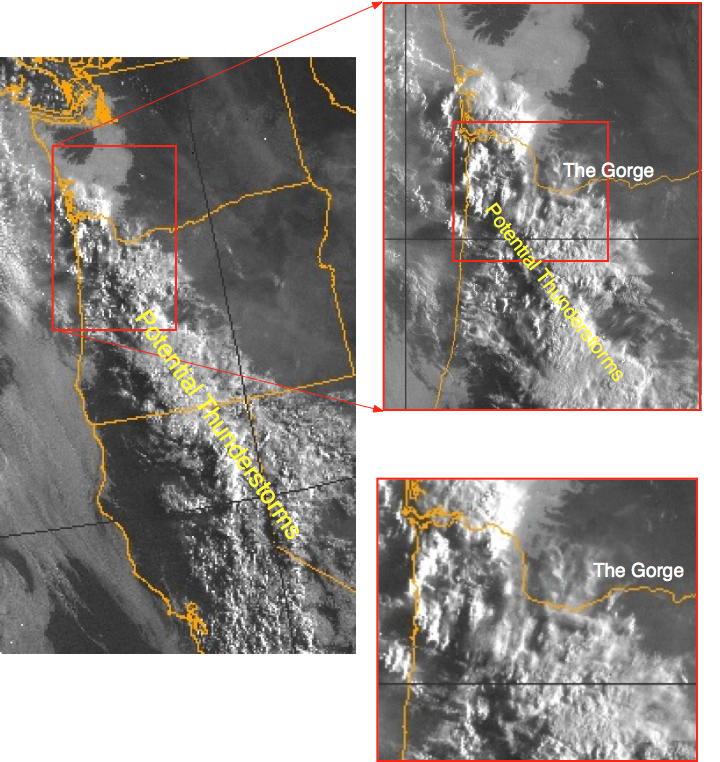
Here is the most recent Bluff report for today. And below is satellite imagery from 7:45 showing the marine layer as a smooth gray layer extending from the ocean and angry potential thunderstorm clouds marching up from California.
Bluff report: Hatchery/Swell - by Mike Godsey @ 7:40 AM: The sensor is reading 17g23 which is way high. The water off the Hatch was glassy until about 15 minutes ago then a windline swept in from the wests. Currently there are small white caps and winds in the 12 to 15 knot range at the Hatch then weaker winds to the west. A few wisps of marine layer clouds are visible in the far corridor.
Satellite imagery shows marine layer clouds over the coast and near PDX. However an enormous mass of convective clouds extends from Santa Barbara, CA. over Portland almost to Seattle. If this mass pushes towards the Gorge it will kill the winds. I will be on the road today so this may be the last report.
| Description: |
|
| Filesize: |
452.97 KB |
| Viewed: |
11445 Time(s) |
|
|
|
| Back to top |
|
|
gmclean
Joined: 08 Mar 2001
Posts: 91
|
| Posted: Sat Aug 18, 2012 9:59 am Post subject: |
|
|
| Thunderstorms look to be a factor already this morning but it is nice to see almost 3mb across the cascades this morning. Models have done a pretty good job with this transition over the past couple of days. In general I think weather prediction models are handling this pattern of a closed low off the coast better than they used to. I have been burned by this pattern in the past trying to nail first day of wind after heat.
|
|
| Back to top |
|
|
jimoakes
Joined: 21 Apr 2006
Posts: 172
|
| Posted: Sat Aug 18, 2012 10:01 am Post subject: |
|
|
OK. To be more specific, here is what my experience is. It can blow for days at a time at Jones as mentioned here. I used to sail Nuclear Ally for many days in a row on a 4.7, when it's hot and dead from Portland to Arlington.
At the end of a streak of those 4.7 days if a real 3.7 afternoon came along and it blew 3.7 or stronger till dark, we would drive to Hood River that night. The next day would be good in the corridor.
Monday 8/13 looked like real 3.7 by the charts at Jones. 8/14 at The Hatch was pretty windy. Last night by the Jones chart it was even windier right up till dark . The key thing to look at for this to happen is strong wind till dark at Jones.
Yes, no guarantees on this, but I'm going to the Hatchery right now and rigging a 3.7 to get ready.
|
|
| Back to top |
|
|
gmclean
Joined: 08 Mar 2001
Posts: 91
|
| Posted: Sat Aug 18, 2012 10:23 am Post subject: |
|
|
To get really strong wind at Jones, The coast has to be socked in with the thermal trough set up over Portland. This is not a pattern that usually sticks around long, at least that is my recollection. You could argue that we had that pattern for the last 2 days but the difference between Thursday and Friday as Jim pointed out was that it blew stronger and longer into the night on Friday. Another difference was the morning wind. Thursday we had easterlies at Jones most of the morning indicating the thermal trough axis was not inland yet. Friday morning was west at Jones.
Thunderstorms could kill the wind or enhance it depending on where they set up local scale high pressure. Either way it wont be a boring weather day 
|
|
| Back to top |
|
|
|

